What Is LiDAR?
LiDAR stands for Light Detection and Ranging, and it uses light to find the range of an object. (see the Wikipedia entry on LiDAR for more information). The LiDAR system we use is composed of several pieces of equipment:
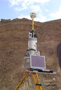
The Scanner itself is a LMS-Z420i, manufactured by Austrian company RIEGL. Developed initially for industrial and surveying work, the LiDAR has proved extremely adept at geological field work, particularly quantifying large scale, and hard to reach outcrops. The scanner uses a Class 1 LASER with a maximum measurement rate of 12,000 points per second.
A Nikon D100 Digital SLR camera provides high resolution colour images to provide colour and texture for the scans. The Camera is mounted above the Scanner and photographs are taken automatically to coincide with the scan data through a controlling Laptop.
In order to Fully georeference the LiDAR data (accurately place the data in a 3D virtual world), a Trimble Differential Global Positioning System (DGPS) is mounted upon the scanner head. With global coverage and sub-meter scale accuracy, this allows scan positions to accurately mapped such that each data point's position in space is very accurately known.
The LiDAR system is controlled by a Panasonic Toughbook laptop. This laptop is ruggedised for field work, incorporating a touch screen which allows successful viewing even with direct sunlight. The laptop runs software to initiate and control the scan, including the Camera and DGPS. It also acts as a portable data storage device to record the scan data. The whole system is powered by a modified Car battery.
Post scan processing is generally performed in the laboratory, although this can be done in the field such that the scanning process can optimised as it is being done. The software used is PolyWorks by InnovMETRIC which provides engineering grade editing and merging of 3D point cloud data. RiSCAN Pro and VRGS are the main interpretation tools for the data.
interpreted within VRGS much in the same way as seismic, such that
key surfaces can be picked and geostatistics can also be extracted to quantify geological systems such as sinuosity of channels, and structural data for modeling of folding and fault geometries. Combinations of scan position can allow geometries of very large bodies to be determined when this is not possible from outcrop. Work at Manchester is currently looking at combining interpreted LiDAR data with hydrocarbon reservoir modeling software so that fluid simulations can be run through the simulated reservoir.