[University home]

LiDAR Research

Welcome

VRGS Screenshot

Our Research

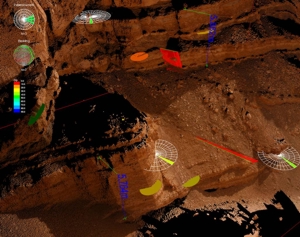
The Basin Studies and Petroleum Geoscience group are world leaders in the use of LiDAR data and quantitative geology in the Earth Sciences. Our research includes applications of terrestrial laser scanning to sedimentology, structural geology, palaeontology, landslip monitoring and teaching. We have developed our own software in-house to help interpret and analyse outcrop data.

We also have our own 3D visualisation facility within the research group.

LiDAR News and events

Jan 2011: Interactive Project Map now available

See where our current and past projects are based!

Jan 2011: North Africa Research Group Fractures Workshop

VRGS Shows whats possible with LiDAR Data

December 2010: New Hydrothermal Dolomites Project Started

High-resolution LiDAR study of Fracturing and Dolomitisation in the Gulf Of Suez.

October 2010: Geomodelling Group at the University of Barcelona now using VRGS

Agreement between Manchester and Barcelona groups pushes forwards the boundaries of LiDAR usage!


More news....